


Researchers at the University of Manchester and University of Sheffield have published a new online interactive map of Manchester to show citizens where the city’s public land is, and to empower the public to make the case to Manchester city council to dispose of this land to meet local needs rather than those of developers and investors.
Through the map, published today, the researchers intend to “improve transparency around public land ownership and use, and to encourage public debate around how land can be better used to address social and environmental needs.”
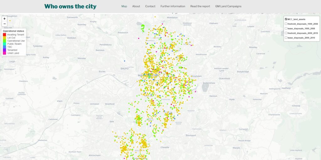
Mancunians can use the map to investigate what public land exists on both a city and neighbourhood level, and can also track Manchester council’s disposal of public land between 1999 and 2019, in the the central wards of Cheetham, Miles Platting & Newton Heath, Ancoats & Beswick, Ardwick, Hulme, Deansgate and Piccadilly.
For decades, Manchester city council, alongside many other local authorities, has sold increasing amounts of public land to developers, providing the space for the building boom dominating Manchester city centre and its outskirts. A boom which has previously failed to provide adequate amounts of social and affordable housing in the city centre.
The Meteor reported on a previous paper by the same geographers who created this map which stated that Manchester city council owned 57% (20,900 acres) of the city’s land in 1982. Guy Shrubsole author of the website and book Who Owns England, estimates that today land ownership by Manchester council is around half that in 1982.
The researchers hope that the map will reverse or slow this historical trend. One of the authors Dr Tom Gillespie, from the University of Manchester, said:
“Mancunians can get clued up on where public land exists, and make the case that this land be disposed of to meet their environmental and social needs — rather than being sold off to developers to build unaffordable apartments as has often been the case with Manchester city council since the 1990s.
“We want to encourage debate about how our land can be used differently to meet environmental and social needs like addressing the climate crisis or the housing crisis
“Mancunians can now investigate whether public land exists on their doorstep, and hold Manchester city council to account over how it’s disposed of. Citizens of Manchester can speak to councillors about land ownership and request land be used for community projects, social housing and green spaces like pocket parks.”

The map adds to a growing debate about how UK cities should begin disposing of land for local needs rather than for turning a quick profit. Last year, the Liverpool Land Commission called on the city council to see land as having social and environmental value rather than a commodity, and recommended the city council realise public land’s social, cultural, economic and environmental potential.
Asked to respond to the online map and the report, Manchester city council said it used public land to support a wide range of requirements to meet agreed strategic objectives, from residential growth, to job creation, open space, cultural space, leisure and education. On the issue of land use in housing, a council spokesperson told the Meteor:
“Land is used to ensure that appropriate and sustainable residential growth is achieved across the city in a managed way across all sectors and tenure types with new homes to a high standard of design and construction.
“The Council is currently on track to meet and exceed the delivery target of 6,400 affordable homes between 2015 and 2025. Now more than 7,000 affordable homes will be delivered in this timescale. More than 20% of all homes built in the city during this time period will be affordable, as per the Council’s target.
“Around 800 affordable homes have been delivered on Council land since 2015 and a further 1,300 expected to be completed on Council land by 2025. This represents around 30% of total affordable homes delivered over this period.”
“With a long-term void rate [unoccupied properties] of only around 1% in the city centre & 0.5% elsewhere in the city – the evidence shows that there remains strong demand for all types of housing in Manchester and all homes that are being built are being used.”
The researchers emphasise that the map is a work in progress, issuing a call to action for Mancunians to build on their work, Gillespie said:
“We’ve mapped the disposal of council-owned land in Manchester’s central wards. We invite others to build on our work and map the city’s suburban wards following the process we used. We invite anyone to contact us using the contact form on the website for guidance on how to do this.”
The Meteor is a media co-operative on a mission to democratise the media in Manchester. To find out more – click here.
Sign up to The Meteor mailing list – click here.
Feature image: The Meteor

Andrew Wigley says
Rights of way are being given to developers to build on at future time so soon there will be no legal right to walk around local areas. Manchester Met University are trying to turn HULME into a mega campus. What happens to local residents?